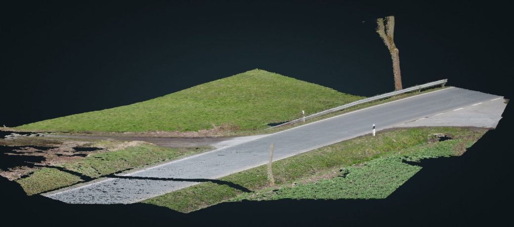
This scene of accident has been imaged in a flight along the road and parallel to the road above the fields and meadows. Due to the inclined point of view only in one direction, a ditch and a one-sided talus resulted in a so-called mountain effect – incomplete areas of the point cloud. If these areas would have been of interest, additional aerial photos, such as in an additional direction along the street, would have been necessary. This effect becomes obvious with the trees, which are computed as one-sided concave shells. Additionally the tree in the foreground results in a kind of shadow, because it hides a part of the street surface on to many photos, so the number of images containing this area of the street is to small for computing the surface points.
At this site an accident between a left-turning vehicle and an overtaking vehicle had happend. At the very beginning of the accident there was a locking between the right front wheel of the overtaking car and the left front wheel of the overtaken car. This locking destroyed the wheel suspension. This canted the wheel and it got jammed. So we got a deep tyre mark on the street. Because the locking happend at the very beginning of the collision the tyre mark starts immediately behind the wheels collision positions. Furthermore the tyre mark described the wheel trajectory of the right front wheel of the overtaking car during its runout. The jammed wheel resulted in a right bend of this trajectory. So even in the case of an optimal acquisition of accident data only the starting point and the final point of the tyre mark and may be an additional supporting point would have been measured. An exact description of the tyre mark and its bending never takes place. Unfortunately in this case no measuremts at all took place. Only some pictures of the scene had been taken. Not even the starting point was measured even though this would have clarified on which half of the road the collision took place. With the point cloud of the area the perspective of the pictures could be reconstructed. It is uniquely specified by the place of the camera, its height above street level, the direction of the camera, the tilt of the axis versus the street, the rotation of the image with respect to its axis and the mathematical focus length. Therefore a sufficient number of geometric marks of the point cloud has to be matched with the coresponding marks in the photo. Beside road paintings eye-catching marks on guard rails, reflector post, road and guide signs and similar marks could be used. After that the picture can be projected onto the point cloud and the color of the point cloud represents pictures color informations. So point cloud expresses the original marks quite exactly. The propable inaccuracy is in the order of magnitude of 3 cm for all parts of the marks and traces. So all marks and traces, which have not been measured on-site but are documented in photographs, could bee reconstructed quite exactly. In this case it got out that not a overtaking maneuver occured. It had been a try to avoid a collision because of a delayed braking action of the following car. Without the accurately reconstructed skid mark this would not have gotten out as a fact. A 3-D presentation of this point cloud is available. On most up-to-date hardware – desktops and laptos as well – the presentation runs in your web-browser. Older hardware and most of the smartphones and tablet will not be able to display the point cloud, because the point cloud is to detailed for that hardware. Examples with reduced point density, which should run on weaker hardware, too, will be prepared in future.Narrow Countryside Road with Branch